 简体中文
简体中文

Australia's latitude and longitude position is out by more than a meter, a team of Australian scientists charged with updating the coordinates has said.
The team from Geoscience Australia is in the process of recalculating the Geocentric Datum of Australia, the national geospatial reference framework, for the first time since 1994.
The updated position, expected to be approximately 1.5 meters further north of the current position, will improve the accuracy of all spatial information in Australia such as transportation, personal navigation and surveying.
Dan Jaksa from Geoscience Australia said updating the framework was important because of the growing difference between the current position and the coordinates used by global navigation satellite systems such as GPS.
"We have points on Australia that are fixed to Australia and the lines of latitude and longitude move with those points," Jaksa told the ABC on Thursday.
"The lines are fixed to the continent but as time goes by, that position compared to a GPS position can create a difference, so every so often we need to change that."
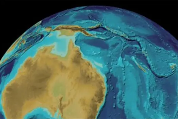
Part of the reason for the changed position is the Indo-Australian tectonic plate, which Australia and parts of New Zealand and Indonesia sit on. It is one of the fastest moving tectonic plates in the world and has caused the significant discrepancy between Australia's recorded position and actual position.
The continent moves north approximately seven centimeters each year, colliding with the Pacific Plate which is moving 11 centimeters west every year.
The new data, to be published early in 2017, will be based on Australia's theorized position in the year 2020 in order to make the new data accurate for longer.
(APD)