简体中文
简体中文

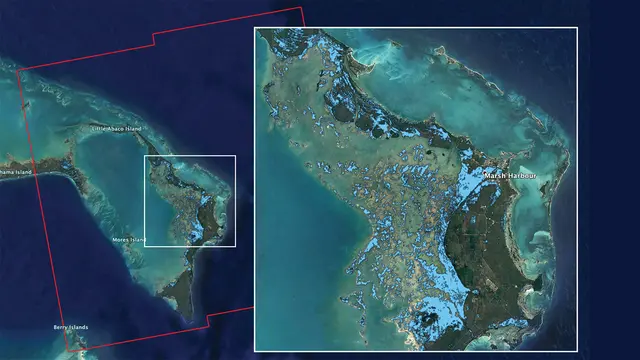
NASA's Advanced Rapid Imaging and Analysis (ARIA) team has produced a flood map of the Bahamas by using data from the European Space Agency (ESA), according to a release of NASA's Jet Propulsion Laboratory (JPL) Tuesday.
NASA's ARIA team analyzed the synthetic aperture radar data provided by the ESA's Copernicus Sentinel-1 satellites, and produced the map.
The light blue color indicates areas that were likely flooded when the data were acquired on Sept. 2. In particular, the map shows flooding in and around Marsh Harbour in the Abaco Islands in the northern Bahamas, according to the release.
The map covers an area of about 176 km by 170 km shown by the large red polygon.
Authorities and responders can use such flood map as a guidance to identify areas that are likely experiencing flooding, said the JPL.
NASA works to leverage the power of views of the Earth from space and research aircraft to assist communities around the world to plan for and recover from a wide range of disasters, such as earthquakes, wildfires and hurricanes.
(ASIA PACIFIC DAILY)