 简体中文
简体中文


A model for tracking air pollution is helping trace the movement of locust swarms, providing early warning to many developing countries.
Developed by the National Oceanic and Atmospheric Administration (NOAA) on the request of the Food and Agriculture Organization (FAO), the application is transmitting precise location and time of locust swarms arrival to governments in African and Asian countries.
"The new tracking system allows issuing of more precise short-term warnings of up to one week in advance," Keith Cressman, senior locust forecasting officer with FAO, told CGTN.
The organization's locust forecasting office also issues long-term warning about the movement of locusts, one to three months in advance.
The combination of long and short-term forecasting will give governments an advantage to prepare for the locust attack. Information based on both warnings will also help authorities to refine and modify the preparations to deal with the crisis, added Cressman.
Bullets, tear gas and beating utensils to ward off locust swarms
Billions of locusts are destroying standing crops in large parts of East Africa, Asia and the Middle East, threatening food supply and livelihoods. Most of these countries with weak health infrastructure are already burdened by coronavirus pandemic.
Recent estimates suggest that more than 20 million people are facing severe food shortages because of the infestation, which has forced countries to take desperate measures.
Kenya, which is witnessing the worst locust infestation in 70 years, ordered police to fire tear gas and used machine guns to kill the insects. Traditional farmers and herdsmen in a desperate attempt are beating their utensils for hours to ward off locusts from their farmland.
A timely forecast about the locust movement could help the government initiate aerial spray to control the locusts from invading the farmland.
These resource-deprived countries have already started deploying aircraft and drones to spray insecticide on the swarms to deal with the situation. But figuring out the exact time and location of the swarms has remained a challenge for them.
"We hope this new tool will help response organizations reduce the devastation that's being wrought by these locust swarms," said Mark Cohen of NOAA's Air Resources Laboratory (ARL) in College Park, Maryland.
Tracking it with the wind
The new web application to track locusts is based on NOAA's HYSPLIT dispersion model – used widely to monitor air pollution from wildfires, volcanoes and industrial accidents.
The FAO approached NOAA to know if the model can be used to forecast the movement and behavior of locusts accurately.
"We realized this was a huge problem, and we absolutely wanted to help in any way we could," said Sonny Zinn, a software engineer at ARL, who played a crucial role in creating the application.
Since locust cannot fly for long on their own, they migrate with the assistance of the wind. The model's ability to provide high-quality data on wind speed and direction helps in predicting the swarm's route. While solitary adults fly at night, swarms migrate during the day.
The forecast model allows for accurate predictions of where the locusts will go and when. It can also be used to indicate potential source areas of desert locust swarms, said NOAA in a statement.
"As we get more information on the science of how they fly, how high they fly, we will be able to make the tool even more accurate," added Zinn.
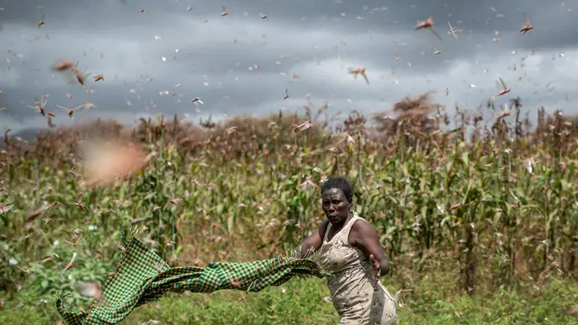
(Cover: A farmer waves her shawl in the air to try to chase away swarms of desert locusts from her crops, in Katitika village, Kitui county, Kenya, January 24, 2020. /AP)