简体中文
简体中文

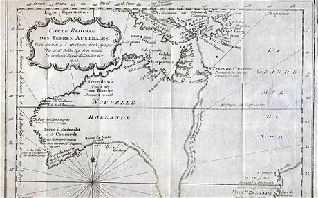
The first map of Australia, produced by Dutch explorers in the 17th century, has arrived in Melbourne for expert analysis, as historians look to preserve the priceless document.
The map of New Holland, the name given to the Australian mainland by famous seafarer Abel Tasman, is the first published record of the previously unexplored continent in the Dutch language.
Created by Dutch East India Company cartographer Joan Blaeu, the 1663 map has formed basis of all subsequent mapping of Australia.
But since uncovered in a Swedish storage facility six years ago and acquired by National Library of Australia in 2013, historians have identified that the priceless artifact is in serious decay.
Subsequently, the National Library of Australia has launched a conservation effort to preserve the important document as an historical record for the benefit of future generations.
Before treatment begins, however, the aging map has been sent to the Victorian capital where University of Melbourne analysis experts will use state-of-the-art technology to identify the material components of the 350-year-old map.
Director-General of the National Library of Australia, Anne-Marie Schwirtlich, said the Melbourne-based experts would play a critical role in the process.
"This will determine the conservation treatment options for consideration by our Curator of Maps and Preservation team before the University (of Melbourne) embarks on the most appropriate treatment," Schwirtlich said in a statement released by the University of Melbourne on Monday.
Senior Paper Conservator from the University of Melbourne, Libby Melzer, explained that the map had deteriorated due to the cartographer's choice to use blue-green paint, believed to be verdigris, to highlight the Australian coastline and other distinguishing features.
"Derived from copper and typically exposed to wine vapors to achieve its vibrant color, verdigris is chemically unstable and has darkened and corroded the surrounding paper, eating through it entirely in some places," Melzer, from the university's Grimwade Centre for Cultural Material Conservation, said in the statement.
"Much of the detail is obscured by a darkened varnish layer and there are many small tears and creases from poor storage before the map was purchased by the Library.
"The conservators have already been able to examine fragments of the map supplied by the National Library of Australia that were unable to be reattached following a previous treatment. The Library has also provided the Grimwade Centre with a large vial of powder containing residues of the varnish they removed in order to reveal some aspects of the image before it went on display in 2013.
"Using the samples of the paper, paints, inks and varnish provided by the Library, we have already begun to use Fourier Transform Infrared (FTIR) spectroscopy to analyze the varnish and the paint binder, and X-Ray Fluorescence (XRF) spectroscopy to look at the pigments and degradation products before we begin further, non-destructive analysis on the map itself."
Once returned to the National Library of Australia in Canberra, three conservators will work on the map for approximately six months, the statement read.
(APD)